![(#164825) Yosemite National Park compiled from Captain Wheeler's Survey (Sheet 56 D and Yosemite and Yosemite Valley Sheet), U.S. Geological Survey (Yosemite Sheet), U.S. Land Office Plats, Lieutenant McClure[']s map, and from notes of scouts made by 1st. Lieut. H. C. Benson, 4th. U.S. Cav. Scale: 1 inch-4 miles. UNITED STATES. DEPARTMENT OF THE INTERIOR.](https://lwcurrey.cdn.bibliopolis.com/pictures/164825.jpg?width=768&height=1000&fit=bounds&auto=webp&v=1682012563)
![Yosemite National Park compiled from Captain Wheeler's Survey (Sheet 56 D and Yosemite and Yosemite Valley Sheet), U.S. Geological Survey (Yosemite Sheet), U.S. Land Office Plats, Lieutenant McClure[']s map, and from notes of scouts made by 1st. Lieut. H. C. Benson, 4th. U.S. Cav. Scale: 1 inch-4 miles.](https://lwcurrey.cdn.bibliopolis.com/pictures/164825_1.jpg?auto=webp&v=1682012563)
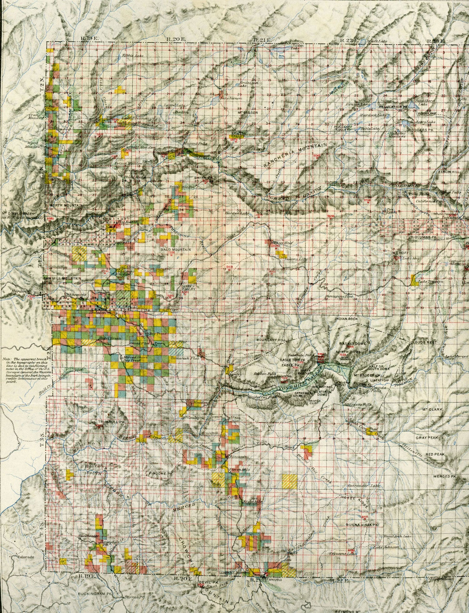
Yosemite National Park compiled from Captain Wheeler's Survey (Sheet 56 D and Yosemite and Yosemite Valley Sheet), U.S. Geological Survey (Yosemite Sheet), U.S. Land Office Plats, Lieutenant McClure[']s map, and from notes of scouts made by 1st. Lieut. H. C. Benson, 4th. U.S. Cav. Scale: 1 inch-4 miles. N[ew] Y[ork]: Julius Bien & Co. Lith., n.d. Map. 31 x 38.5 cm; 12 1/4 x 15 1/4 inches (including borders); 27 x 36.4 cm; 10 5/8 x 11 13/16 inches (within border). A detailed map color coded to show various types of patented lands, but with no legend present to determine land types. The topography is overlaid with the usual grid pattern of the Land Office surveying system. A printed note near the left margin states that a small section was left blank due to conflicting information: "Note: The apparent break in the line is due to conflicting notes in the Office of the U.S. Surveyor General, the Western boundary of the Park being in reality continuous at this point." This map is based on the 37 x 54 cm "Topographical Map of the Yosemite Valley and Vicinity" (sheet 56D). First published in November 1883, it was for many years the standard map of the region. Small areas of light toning, two tiny pin holes only visible when held to light, very good overall. (#164825).
"Coming Soon"