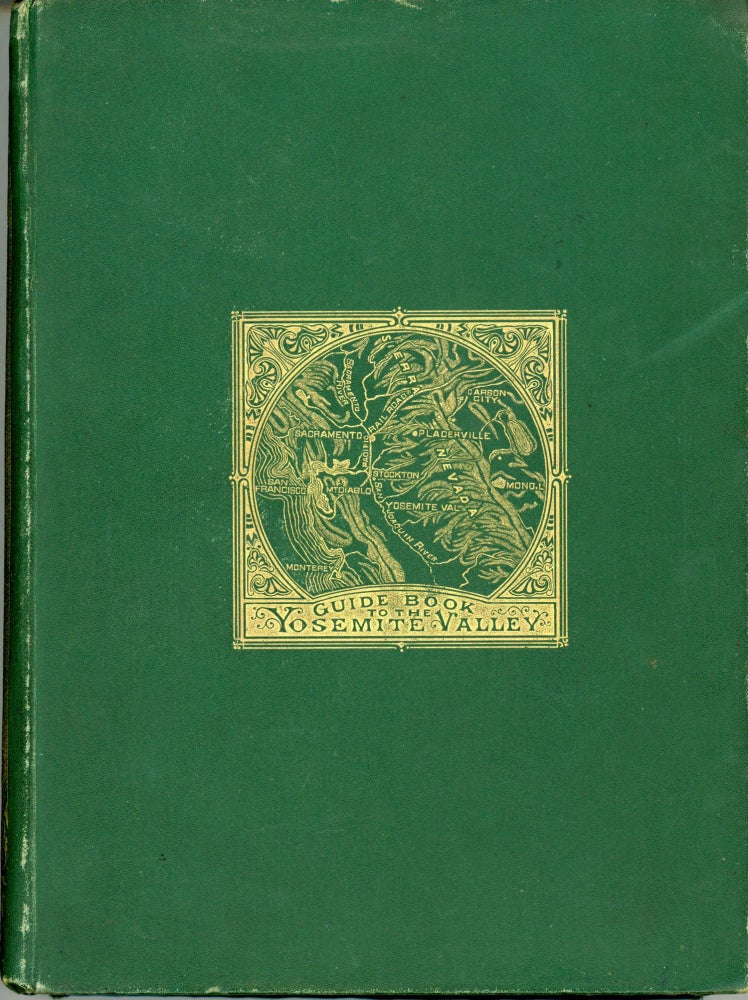
The Yosemite guide-book: a description of the Yosemite Valley and the adjacent region of the Sierra Nevada, and of the big trees of California, illustrated by maps and woodcuts. [Sacramento]: Published by Authority of the Legislature, 1869. 22.8x16.5 cm (octavo), pp. [i-v] vi-vii [viii] [9] 10-155 [156: blank], flyleaves at front and rear, 8 plates with tissue guards, 20 illustrations in text, 2 folded maps (in front and rear pockets), title page printed in red and black, original pictorial green cloth, front, spine and rear panels stamped in gold, brown coated endpapers. First edition, first printing. At head of title: "Geological Survey of California. / J. D. Whitney, State Geologist." Printer's imprint on copyright page: "University Press: Welch, Bigelow, & Co., / Cambridge." A single sheet, printed on recto only, headed "Supplementary Notice. [From the San Francisco Bulletin of May 28, 1869.]" is inserted facing page 48. The two maps are identical to those issued with The Yosemite Book, except the "Map of the Yosemite Valley ..." is not tinted. The most influential publications of the California Geological Survey were the series of Yosemite guidebooks published between 1869 and 1874. These publications were intended to serve as tourist guides to the Yosemite region and various groves of giant sequoia. There were two printings of the first edition of the guidebook. For the most part, the text follows that of the earlier The Yosemite Book (1868). In a "prefatory note" dated "May 1, 1869," Whitney remarks that "some verbal changes have been made, and a few pages added." The added material, appearing on pages 112-133, provided a description of the high country at the head of the Kings and the Kern and the watershed of the south and middle forks of the San Joaquin, based upon the explorations of the survey's field party of 1864. The photographs used to illustrate The Yosemite Book were replaced with woodcuts selected from those used in Geology. Volume I (1865). The maps accompanying the first printing of the first edition of the guidebook were identical to those appearing in The Yosemite Book, but "Map of Yosemite Valley ..." was not tinted. A revised version of the "Map of Yosemite Valley" appeared in copies of the second printing. The first printing was issued in the fall of 1869 with a print run of 1000 copies. A second printing of 800 copies was issued the following year. The first pocket edition, containing two small folding maps but no illustrations, was issued in 1871. This edition was sold at one dollar per copy and was well received by the public "on account both of its cheapness and its portability." The first printing of a thousand copies was followed by a second thousand produced in the spring of 1872. This second printing contained a revised "Map of the Routes from San Francisco to the Yosemite Valley," but was otherwise identical to the first printing. The text of this first pocket edition followed that of the 1869 and 1870 printings of the guidebook. However, it was Whitney's expressed intent to improve successive editions to provide "something more solid than can be got from the ordinary guide-books and works of travel, which are chiefly devoted to scraps of personal adventure." To expand descriptions and to provide current information, additional field work was performed in the Yosemite back country between the Merced and Tuolumne rivers by Whitney, Hoffmann, and Craven in the summer of 1873. Whitney hoped to extend the scope of a new edition to "give more space to the description of other portions of the Sierra Nevada, making the work a kind of scientific guide to the whole chain." A new edition was published in 1874, but Whitney's intent was not realized. The maps were improved and information about the Yosemite region was revised and somewhat expanded, but much of the information on the high country south of Yosemite, based on the 1864 field work, was omitted. The series of Yosemite guidebooks influenced the literature on Yosemite which followed, becoming the frequent source of quotations in numerous other books about the region. The guidebooks contain information that is still useful and much of the historical material is of interest. "Although these guide-books are long out of date, they have a literary quality that preserves their value" was Francis P. Farquhar's apt appraisal in his essay "The Literature of the High Sierra," The Quarterly News-Letter of the Book Club of California, 2 (December 1934), 8. See Farquhar (1948), title 7. Currey and Kruska 61. Farquhar 7b. Some wear to spine ends and along outer joints and fore-edges, a very good copy. The "Map of the Yosemite Valley ..." is split into three pieces along vertical folds, but nothing is missing. The maps are printed on very thin, cheap paper stock and subject to wear and tear from folding and refolding. For this book, quite a decent copy. Provenance: Bookplate of Stephen Wright Kellogg affixed to the front paste-down. (#166209).
No statement of printing.