![(#167952) Southern Pacific Company Pacific System. Through time schedules double daily and weekly limited passenger train service by the central route, Salt Lake, Ogden, Reno, Sacramento, Oakland, San Francisco, San Jose and Los Angeles[.] A. N Towne, General Manager. T. H. Goodman, Gen. Pass. & Ticket Agent. J. C. Stubbs, Gen. Traffic Manager. R. A. Donaldson, Asst. G. P. and T. Agent. General Offices, San Francisco. SOUTHERN PACIFIC COMPANY PACIFIC SYSTEM.](https://lwcurrey.cdn.bibliopolis.com/pictures/167952.jpg?width=768&height=1000&fit=bounds&auto=webp&v=1682014716)
![Southern Pacific Company Pacific System. Through time schedules double daily and weekly limited passenger train service by the central route, Salt Lake, Ogden, Reno, Sacramento, Oakland, San Francisco, San Jose and Los Angeles[.] A. N Towne, General Manager. T. H. Goodman, Gen. Pass. & Ticket Agent. J. C. Stubbs, Gen. Traffic Manager. R. A. Donaldson, Asst. G. P. and T. Agent. General Offices, San Francisco.](https://lwcurrey.cdn.bibliopolis.com/pictures/167952_1.jpg?auto=webp&v=1682014716)
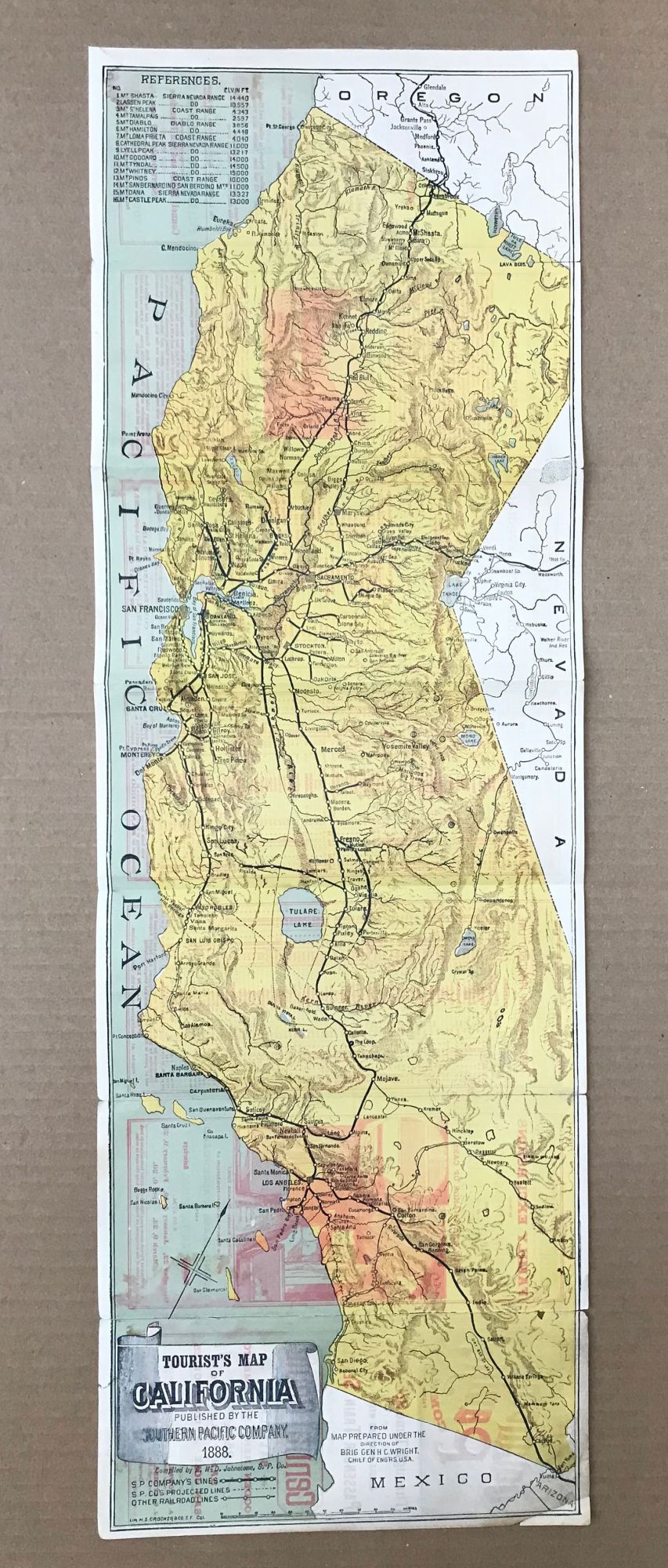
Southern Pacific Company Pacific System. Through time schedules double daily and weekly limited passenger train service by the central route, Salt Lake, Ogden, Reno, Sacramento, Oakland, San Francisco, San Jose and Los Angeles[.] A. N Towne, General Manager. T. H. Goodman, Gen. Pass. & Ticket Agent. J. C. Stubbs, Gen. Traffic Manager. R. A. Donaldson, Asst. G. P. and T. Agent. General Offices, San Francisco. San Francisco: Crocker & Co's Print, 1888. Single sheet, 23.4x75 cm, folded to make 14 panels. At head of title: "No. 49. DECEMBER 1888." Verso is a seven-panel color map, 23.4x75 cm, "Tourist's Map of California published by the Southern Pacific Company, 1888. Compiled by E. McD. Johnstone, S. P. Co. From Map Prepared Under the Direction of Brig. Gen. H. C. Wright. Chief of Eng'rs. U. S. A.", lithographed by H. S. Crocker & Co., San Francisco. The map shows the company's line, projected lines and other railroad lines. The map and text emphasizes California resorts and recreation, including "references," a list of sixteen mountains and mountain regions, from Mt. Shasta south to the San Bernardino mountains, including Mt. Lyell, Mt. Whitney and three other peaks in the High Sierra. The text highlights "Gems of the Sierra," a one-column description of Lake Tahoe and vicinity. Another column is devoted to "pleasure and tourist resorts of the Pacific Coast ... best reached by the several lines of the Southern Pacific Company ... from San Francisco." The eight featured destinations include the Calaveras Big Trees by way of Milton and Yosemite by way of Berenda and Raymond. There was an earlier version of the map only (verso blank) for 1887 (printed December 1886). This is the earliest, or among the earliest, version with both time table, promotional material, and the map. Splits along several folds, some soiling and staining, a good copy. (#167952).
Printer's code "11-27-88. (20.20)" at bottom edge of front panel."