![(#167954) AUTOMOBILE CLUB OF SOUTHERN CALIFORNIA STRIP MAPS [with] INDEX TO STRIP MAPS IN CALIFORNIA. Automobile Club of Southern California.](https://lwcurrey.cdn.bibliopolis.com/pictures/167954.jpg?width=768&height=1000&fit=bounds&auto=webp&v=1682014716)
![AUTOMOBILE CLUB OF SOUTHERN CALIFORNIA STRIP MAPS [with] INDEX TO STRIP MAPS IN CALIFORNIA ...](https://lwcurrey.cdn.bibliopolis.com/pictures/167954_1.jpg?auto=webp&v=1682014716)
![AUTOMOBILE CLUB OF SOUTHERN CALIFORNIA STRIP MAPS [with] INDEX TO STRIP MAPS IN CALIFORNIA ...](https://lwcurrey.cdn.bibliopolis.com/pictures/167954_2.jpg?auto=webp&v=1682014717)
![AUTOMOBILE CLUB OF SOUTHERN CALIFORNIA STRIP MAPS [with] INDEX TO STRIP MAPS IN CALIFORNIA ...](https://lwcurrey.cdn.bibliopolis.com/pictures/167954_3.jpg?auto=webp&v=1682014717)
![AUTOMOBILE CLUB OF SOUTHERN CALIFORNIA STRIP MAPS [with] INDEX TO STRIP MAPS IN CALIFORNIA ...](https://lwcurrey.cdn.bibliopolis.com/pictures/167954_4.jpg?auto=webp&v=1682014717)
![AUTOMOBILE CLUB OF SOUTHERN CALIFORNIA STRIP MAPS [with] INDEX TO STRIP MAPS IN CALIFORNIA ...](https://lwcurrey.cdn.bibliopolis.com/pictures/167954_5.jpg?auto=webp&v=1682014717)
![AUTOMOBILE CLUB OF SOUTHERN CALIFORNIA STRIP MAPS [with] INDEX TO STRIP MAPS IN CALIFORNIA ...](https://lwcurrey.cdn.bibliopolis.com/pictures/167954_6.jpg?auto=webp&v=1682014717)
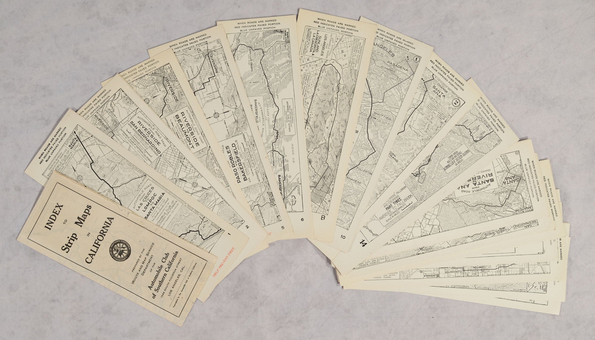
AUTOMOBILE CLUB OF SOUTHERN CALIFORNIA STRIP MAPS [with] INDEX TO STRIP MAPS IN CALIFORNIA. Los Angeles, Cal. Prepared by the Route and Map Service Department of the Automobile Club of Southern California, 1344 South Figueroa Street, v.d. 1916-1919. A complete run of the Automobile Club of Southern California strip maps, from number 1 through number 135, each measuring 9.5x26.8 cm (3 3/4 x 10 1/2 inches), plus the folded index sheet opening to 18.7x56.4 cm (7 3/8 x 22 inches). At least a third of the maps are copyright 1915-1919, the remainder are not dated but are from the late teens to the early twenties. The set of 135 California maps is accompanied by the first four parts of "Automobile Road Map Los Angeles to Ely via the Midland Trail" (numbers 200-203) and the complete five-part "Automobile Road Map from Salt Lake City to Yellowstone National Park" (numbers 250-254). These early strip maps were issued when improvement of roads for automobile use, especially outside of urban areas, was just beginning (the Good Roads campaign, completion of the Lincoln Highway, America's first transcontinental automobile route, etc.). They include topographic and other details lacking in later versions which focused on the expanding road networks. There are a number of informative, early maps of roads in the Sierra Nevada and travelers' services along those routes. The Yosemite National Park routes (by way of Fresno and by way of Stockton) are copyright 1916, Huntington Lake is copyright 1916, Mono Lake region is copyright 1917, Tioga Road is copyright 1916 and the Sequoia National Park route is copyright 1915. Complete sets of the California strip maps are rare. The maps and index are housed in the original ACSC accordion-style stiff paper portfolio. The strip maps are fine. The folded index map has some small wormholes in the upper left third of the map. The portfolio has minor edge wear. (#167954).
"Coming Soon"