
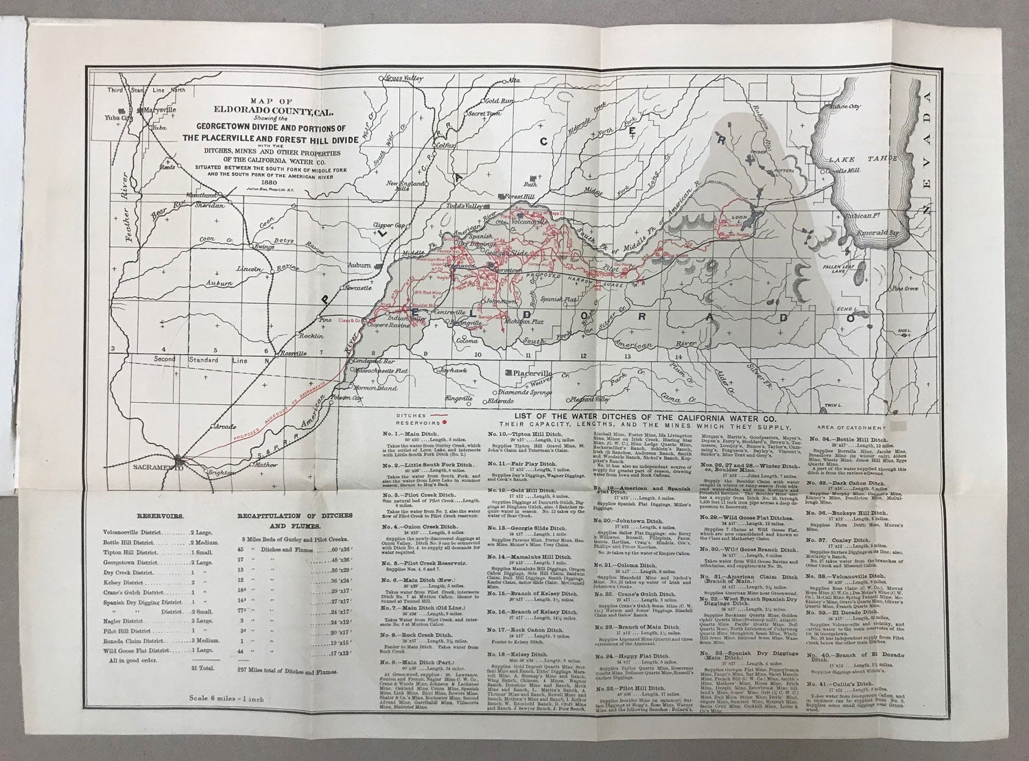
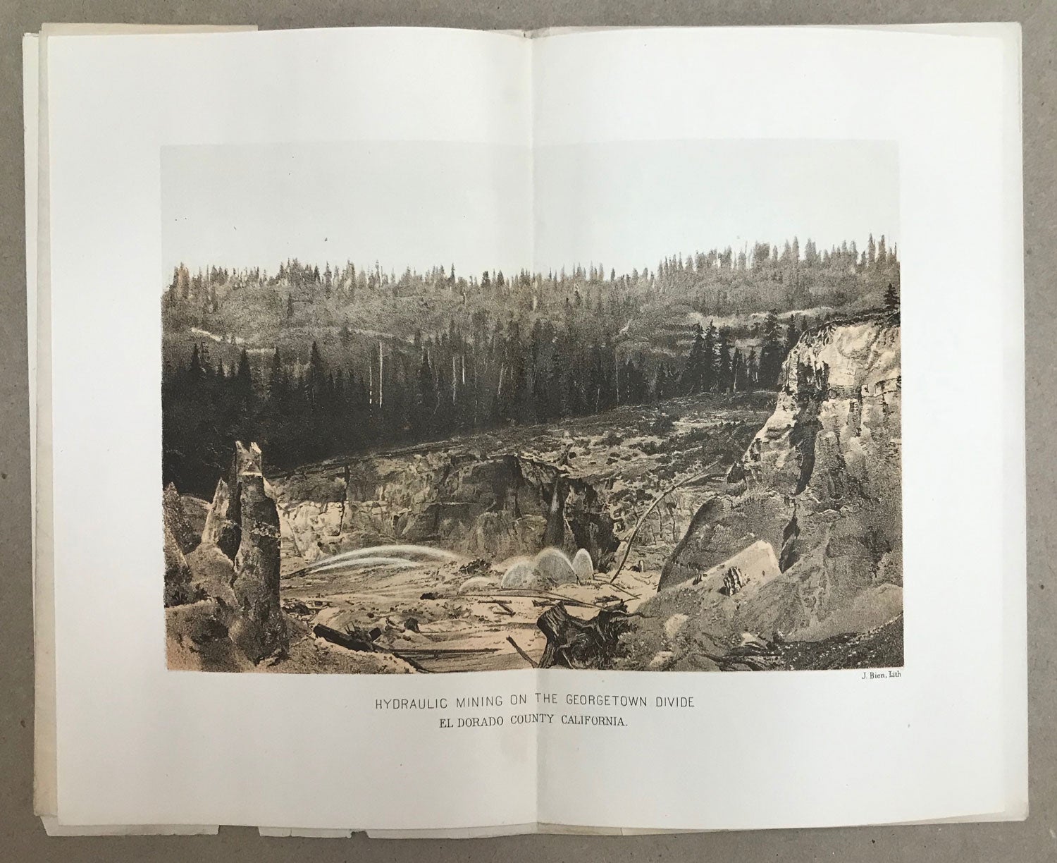
CALIFORNIA WATER AND MINING CO., NO. 115 BROADWAY, NEW YORK, ROOMS 51 TO 57 BOREEL BUILDING. CAPITAL, $10,000,000. SHARES, 500,000. PAR VALUE, $20. BANKERS AND REGISTRARS -- AMERICAN EXCHANGE NATIONAL BANK. New York: David H. Gildersleeve, Printer, 101 Chambers Street, 1880. 23.5x15 cm, pp. [1-3] 4-6 [7-8: blank] 1-4a 1-26b 1-4c 1-6d 1-7e [8e: blank], 1 double page plate with photographic illustration lithographed by J. Bien, 1 folded map, original blue wrappers printed in black. First edition. The folded map, 41x48 cm (16x19 inches), is "Map of El Dorado County, Cal. Showing the Georgetown Divide and Portions of the Placerville and Forest Hill Divide[.] Ditches, Mines and Other Properties of the California Water Co. Situated Between the South Fork of Middle Fork and the South Fork of the American River[.] 1880[.] Julius Bien, Photo-Lith. N. Y." The map, scale 6 miles = 1 inch, shows the company's water system which included 21 reservoirs and 257 miles of water ditches and flumes, as well as the proposed aqueduct to carry water to Sacramento and the proposed narrow gauge railroad from Greenwood to Lake Tahoe by way of Georgetown. The five appendixes are: "Report upon the Property of the California Water Company" by Prof. W. Ashburner; "Report upon the Mining and Other Property of the California Water Company" by E. P. Hutchins; "Report upon the Properties of the California Water Company" by George W. Swan; "Extracts from the Report of Professor Amos Bowman, Made to the California Water Company in 1874; and "Extract from the Report of Professor Rossiter W. Raymond." A prospectus, one of several issued by the California Water and Mining Company following Amos Bowman's extensive 225-page REPORT ON THE PROPERTIES AND DOMAIN OF THE CALIFORNIA WATER COMPANY ... (San Francisco: A. L. Bancroft and Company, 1874). The largest owner of water rights on the Georgetown Divide was the California Water Company, owned by a group of San Francisco investors. The company also owned mining property, including hydraulic mines. Ultimately the company owned more than 250 miles of ditches, flumes and iron pipes. The company hired Amos Bowman to appraise the company's assets. His 1874 report recommended that the company expand their mining activity in addition to being a water company which would increase the company's profitability and build the region's population. Bowman felt the company's water system could by utilized by the city of Sacramento. "However, development never occurred on this divide and though mining and agriculture increased for a time, both pretty much died out by the turn of the century" (Jean E. Starns, "Historic Mining Ditches of El Dorado County, California"). Not in Cowan (1933). Not in Rocq (1970), although see 1763 for a similar prospectus. Several tape reinforcements along spine fold, wrappers worn and lightly chipped along top and bottom edges, a good copy. Map and plate in excellent condition. OCLC reports 4 copies. (#166767).
Price: $850.00
No statement of printing.