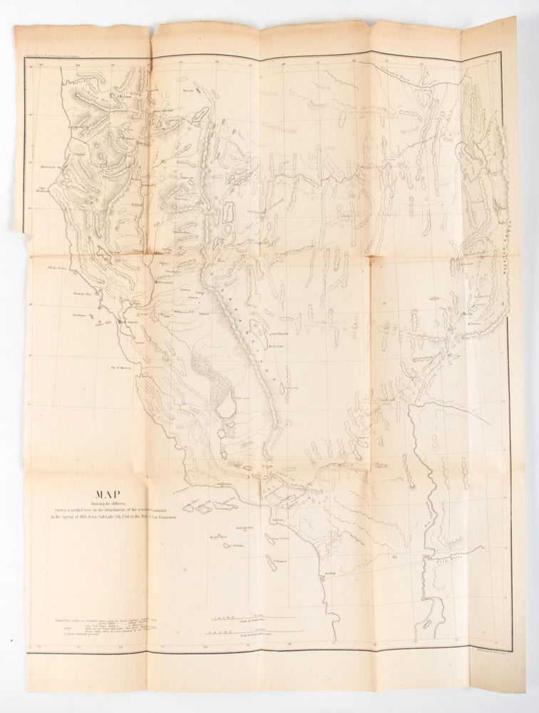
MAP SHOWING THE DIFFERENT ROUTES TRAVELLED OVER BY THE DETACHMENTS OF THE OVERLAND COMMAND IN THE SPRING OF 1855 FROM SALT LAKE CITY, UTAH TO THE BAY OF SAN FRANCISCO. [Washington, 1855.]. Lithographed map, 56.2x46.7 cm (22 1/4 x 18 1/2 inches). Imprint at lower right: "Ackerman Lith 319 Broadway N. Y." The map accompanied two letters of Rufus Ingalls to the Quartermaster General, collected in REPORT OF THE SECRETARY OF WAR, 1855, pp. 152-168, reporting a trip to California from Fort Leavenworth in 1854-1855. From Salt Lake Lieutenant Colonel E. J. Steptoe went on to California by the emigrant route. "Ingalls with a detachment of cavalry left the command at Lassen's Meadows on the Humboldt, June 14, 1855, and went by way of Goose Lake and then through Applegate Pass to Fort Lane, on the Rogue River in Oregon, then past Yreka and Fort Jones to the Sacramento Valley" (Wagner, Camp and Becker, The Plains & the Rockies [1982] 256). The routes of Colonel Steptoe, Captain Ingalls and Lieutenant Mowry are shown on the map. Wheat devotes over two pages on this map, calling it "a document of first quality, showing as it does so well, three important routes" (Wheat Transmississippi 868). Some tanning to map along folds, several short tears and splits along folds, two at intersections, some wear and two chips from upper margin, border along the lower left margin trimmed for folding into the report; good. (166895).
Price: $650.00
"Coming Soon"