![(#167376) MT. TAMALPAIS SAN FRANCISCO SAN FRANCISCO'S GREATEST TOURIST ATTRACTION OVERLOOKING THE GOLDEN GATE MT. TAMALPAIS & MUIR WOODS RY. [front panel title]. MUIR WOODS NATIONAL MONUMENT OF SEQUOIAS SAN FRANCISCO'S BIG TREES THE ONLY NATIONAL PARK OR MONUMENT OF SEQUOIAS ACCESSIBLE EVERY DAY OF THE YEAR MT. TAMALPAIS & MUIR WOODS RY. [rear panel title]. California, Marin County, Mt. Tamalpais, Muir Woods Railway.](https://lwcurrey.cdn.bibliopolis.com/pictures/167376.jpg?width=768&height=1000&fit=bounds&auto=webp&v=1682014123)
![MT. TAMALPAIS SAN FRANCISCO SAN FRANCISCO'S GREATEST TOURIST ATTRACTION OVERLOOKING THE GOLDEN GATE MT. TAMALPAIS & MUIR WOODS RY. [front panel title]. MUIR WOODS NATIONAL MONUMENT OF SEQUOIAS SAN FRANCISCO'S BIG TREES THE ONLY NATIONAL PARK OR MONUMENT OF SEQUOIAS ACCESSIBLE EVERY DAY OF THE YEAR MT. TAMALPAIS & MUIR WOODS RY. [rear panel title].](https://lwcurrey.cdn.bibliopolis.com/pictures/167376_1.jpg?auto=webp&v=1682014124)
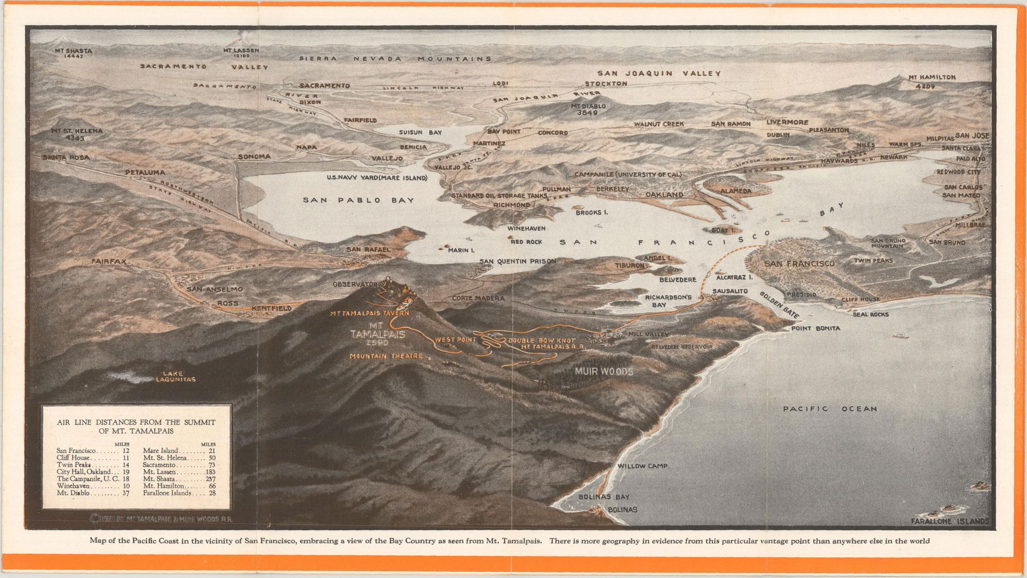
MT. TAMALPAIS SAN FRANCISCO SAN FRANCISCO'S GREATEST TOURIST ATTRACTION OVERLOOKING THE GOLDEN GATE MT. TAMALPAIS & MUIR WOODS RY. [front panel title]. MUIR WOODS NATIONAL MONUMENT OF SEQUOIAS SAN FRANCISCO'S BIG TREES THE ONLY NATIONAL PARK OR MONUMENT OF SEQUOIAS ACCESSIBLE EVERY DAY OF THE YEAR MT. TAMALPAIS & MUIR WOODS RY. [rear panel title]. [San Francisco]: Mt. Tamalpais & Muir Woods Railway, n.d. [1923]. Single sheet, 23x82 cm, folded to make 16 panels, 23x10.2 cm. 7 illustrations from photographs, including 2 on outer panels, 1 birdseye view. Imprint: "SUNSET PRESS, SAN FRANCISCO" at the bottom edge of last panel. Advertising brochure printed in orange and black with a four-panel birdseye view from the summit of Mt. Tamalpais, "Map of the Pacific Coast in the Vicinity of San Francisco, Embracing a View of the Bay Country as Seen from Mt. Tamalpais," measuring 9 x 16 inches, copyright 1923, and a six-panel photographic panorama of the mountain from the tavern and summit on the left to San Francisco and the south Bay on the right. The photographic panorama was probably made by California photographer Theodore Clemens Wohlbrück (1879–1936). "The Mount Tamalpais & Muir Woods Railway was a scenic tourist railway operating between Mill Valley and the east peak of Mount Tamalpais in Marin County, California, covering a distance of 8.19 miles (13.18 km), with a 2.88 mile (4.63 km) spur line to the Muir Woods. The railroad was incorporated in January 1896, and closed in the summer of 1930 ... Billed as the 'Crookedest Railroad in the World,' the line was renowned for its steep and serpentine route, winding through picturesque terrain to a mountaintop tavern providing first-class hospitality and panoramic views of the San Francisco Bay Area. Despite its popularity, the railway met its demise following a fire in 1929, and dwindling ridership when the automobile could finally drive to Tamalpais' summit" (Wikipedia). Not in Rocq (1970), but see 5009 and 5010 for similar brochures. Several folds rubbed, a very good copy. (#167376).
Price: $850.00
No statement of printing.