![(#168611) THE SUMMIT LAKE LANDS THE KINGDOM OF KINGS RIVER THE SUMMIT LAKE INVESTMENT COMPANY 553 SOUTH SPRING ST. LOS ANGELES CALIFORNIA [cover title]. California, Fresno County.](https://lwcurrey.cdn.bibliopolis.com/pictures/168611.jpg?width=768&height=1000&fit=bounds&auto=webp&v=1682014889)
![THE SUMMIT LAKE LANDS THE KINGDOM OF KINGS RIVER THE SUMMIT LAKE INVESTMENT COMPANY 553 SOUTH SPRING ST. LOS ANGELES CALIFORNIA [cover title].](https://lwcurrey.cdn.bibliopolis.com/pictures/168611_1.jpg?auto=webp&v=1682014889)
![THE SUMMIT LAKE LANDS THE KINGDOM OF KINGS RIVER THE SUMMIT LAKE INVESTMENT COMPANY 553 SOUTH SPRING ST. LOS ANGELES CALIFORNIA [cover title].](https://lwcurrey.cdn.bibliopolis.com/pictures/168611_2.jpg?auto=webp&v=1682014890)
![THE SUMMIT LAKE LANDS THE KINGDOM OF KINGS RIVER THE SUMMIT LAKE INVESTMENT COMPANY 553 SOUTH SPRING ST. LOS ANGELES CALIFORNIA [cover title].](https://lwcurrey.cdn.bibliopolis.com/pictures/168611_3.jpg?auto=webp&v=1682014890)
![THE SUMMIT LAKE LANDS THE KINGDOM OF KINGS RIVER THE SUMMIT LAKE INVESTMENT COMPANY 553 SOUTH SPRING ST. LOS ANGELES CALIFORNIA [cover title].](https://lwcurrey.cdn.bibliopolis.com/pictures/168611_4.jpg?auto=webp&v=1682014891)
![THE SUMMIT LAKE LANDS THE KINGDOM OF KINGS RIVER THE SUMMIT LAKE INVESTMENT COMPANY 553 SOUTH SPRING ST. LOS ANGELES CALIFORNIA [cover title].](https://lwcurrey.cdn.bibliopolis.com/pictures/168611_5.jpg?auto=webp&v=1682014891)
![THE SUMMIT LAKE LANDS THE KINGDOM OF KINGS RIVER THE SUMMIT LAKE INVESTMENT COMPANY 553 SOUTH SPRING ST. LOS ANGELES CALIFORNIA [cover title].](https://lwcurrey.cdn.bibliopolis.com/pictures/168611_6.jpg?auto=webp&v=1682014891)
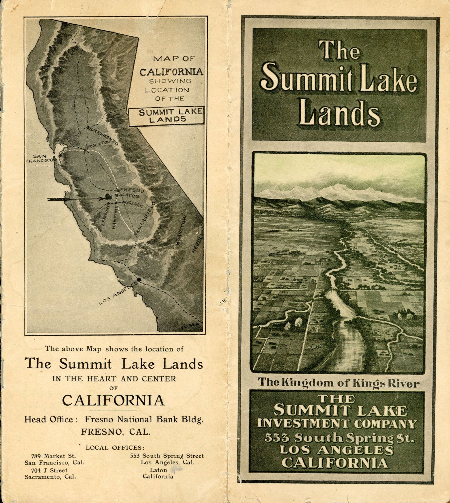
THE SUMMIT LAKE LANDS THE KINGDOM OF KINGS RIVER THE SUMMIT LAKE INVESTMENT COMPANY 553 SOUTH SPRING ST. LOS ANGELES CALIFORNIA [cover title]. [Fresno, Cal. The Summit Lake Investment Company, n.d. [circa 1912?]. 23x20.2 cm, folded to 23x10.1 cm, pp. [1] 2-9 [10-13] 14-15 [16-17] 18-19 [20-24], 12 illustrations from photographs, 4 drawings, including one on front panel, 2 maps, self wrappers, stapled. A brochure offering land in California's San Joaquin Valley along the Kings River southwest of Fresno. It promotes the economic advantages and possibilities in the region, mostly agricultural, and is richly illustrated with photographs of livestock and alfalfa fields. The land was sold in parcels of 10 to 160 acres. It includes a fine 4-panel (7 x 14 1/2 inches) bird's eye view of the region, "Looking East over Summit Lake Lands, showing the High Sierras, the source of the water supply of the Kings River, the principal towns and railroads ... ," which shows the Summit Lake subdivision, as well as the Laguna de Tache Ranch on its eastern border, "where we have settled nearly 6000 people. This is one of the most successful colonies in California." These lands were a small part of a huge Mexican land grant made in 1843 (originally eleven square leagues) acquired by Charles A. Laton and Llewellyn A. Nares in 1896 from the heirs of D. Jeremiah Clark, who had acquired a large part of the Laguna de Tache ranch. The Huntington Library has an undated map (circa late 1890s) of the Laguna de Tache and Summit Lake Lands subdivisions. Not in Rocq (1970). Some edge wear, a sound, good copy. No copies reported by OCLC. Rare. (#168611).
Price: $750.00
No statement of printing.